


HARVEL Voting District, Montgomery County, Illinois
About
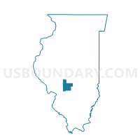
Outline

Summary
| Unique Area Identifier | 573653 |
| Name | HARVEL Voting District |
| County | Montgomery County |
| State | Illinois |
| Area (square miles) | 18.02 |
| Land Area (square miles) | 18.02 |
| Water Area (square miles) | 0.00 |
| % of Land Area | 100.00 |
| % of Water Area | 0.00 |
| Latitude of the Internal Point | 39.39258310 |
| Longtitude of the Internal Point | -89.55946100 |
Maps


Graphs
Select a template below for downloading or customizing gragh for HARVEL Voting District, Montgomery County, Illinois


Neighbors
Neighoring Voting District (by Name) Neighboring Voting District on the Map
- BOIS D'ARC 1 Voting District, Montgomery County, IL
- KING Voting District, Christian County, IL
- PITMAN Voting District, Montgomery County, IL
- RAYMOND Voting District, Montgomery County, IL
- ZANESVILLE Voting District, Montgomery County, IL
Top 10 Neighboring County Subdivision (by Population) Neighboring County Subdivision on the Map
- Raymond township, Montgomery County, IL (1,200)
- Bois D'Arc township, Montgomery County, IL (956)
- Pitman township, Montgomery County, IL (508)
- Zanesville township, Montgomery County, IL (491)
- King township, Christian County, IL (244)
- Harvel township, Montgomery County, IL (243)
Top 10 Neighboring Place (by Population) Neighboring Place on the Map
Top 10 Neighboring Unified School District (by Population) Neighboring Unified School District on the Map
- Panhandle Community Unit School District 2, IL (3,358)
- Morrisonville Community Unit School District 1, IL (1,898)